Mao Gong Shi Coastal Recreation Area
Taiwan · Kinmen County · 烈嶼鄉 · Nature & Scenery
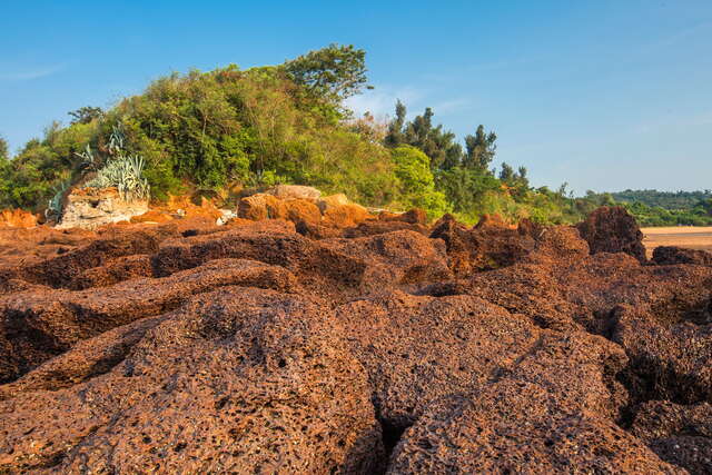
Image source: Taiwan_Opendata; license credits as shown.
Overview
Mao Gong Shi Coastal Recreation Area is located on the north side of Little Kinmen Island and is named after the distinctive red stone known as Mao Gong Shi. It is one of the few places in Taiwan where Mao Gong Shi can be found.
Highlights
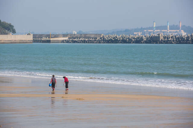
Mao Gong Shi Coastal Recreation Area is a seaside trail destination that combines distinctive red geological scenery with wartime landscape features. Located on the northern coast of Little Kinmen (Lieyu), it offers views across the water toward Xiamen and nearby offshore islands. The coastline is lined for about one kilometer with rare iron-cemented rock formations known as Mao Gong Shi, making this one of the few places in Taiwan where this rust-red honeycomb rock can be seen up close. At low tide, visitors can walk into the intertidal zone and experience its otherworldly rock formations. The seashore is equipped with connected walking paths and viewing platforms, and along the way visitors can see anti-landing obstacles, military outposts, and other historical remnants, creating an atmosphere that blends nature with cultural and military history.
What to See
1. Red honeycomb rock terrain of Mao Gong Shi: Mao Gong Shi is an iron-cemented rock composed of minerals such as iron, silicon, aluminum, and calcium. After years of wind and sea erosion, it has developed a rust-red, porous honeycomb-like appearance. The rocks vary in size and are scattered across the beach and pebble shore. 2. About one kilometer of Mao Gong Shi coastline: Along the roughly one-kilometer stretch of beach and shoreline, Mao Gong Shi rocks are piled across the coast. Some are only tens of centimeters wide, while others reach several meters or spread into flat rock platforms covering hundreds of square meters. They become exposed at low tide and are ideal for seaside walks and scenic viewing. 3. Cape and twin-bay scenery: The Mao Gong Shi coast sits on a headland at the northernmost point of Lieyu, with inward-curving bays on both sides. This creates a coastline of alternating capes and bays, where the contrast between red rocks and blue sea is especially striking. 4. Anti-landing obstacles and wartime relics: On the beach, visitors can see prominent ring-shaped anti-landing rail barriers, once part of the Republic of China military’s coastal defense system. Nearby are remains of military facilities such as No. 6 Barracks (L34-44 position), presenting a vivid picture of the island’s former frontline defenses. 5. Coastal viewing platforms and panoramic views: The area includes coastal scenic zones and viewing platforms. In good weather, visitors can look across to Xiamen City and Lion Islet, and enjoy the sea-and-sky horizon as well as sunsets reflected on the red Mao Gong Shi rocks. 6. Intertidal zone and oyster-farm scenery: When the tide goes out, a broad intertidal zone appears. Local residents use this area for oyster farming, so visitors can observe traditional coastal aquaculture and the character of local fishing village life.
Address
No. 60, Xilu, Poutou, Huangpu Village, Lieyu Township, Kinmen County 894 Phone: (08) 2362500
Travel Tips
1. Best time and season to visit: A sunny day with stable weather and good visibility, especially during the dry and cooler autumn and winter months, is the most suitable time to visit Mao Gong Shi Coastal Recreation Area. The air is more comfortable and the views are clearer, making it ideal for seaside walks and distant views of Xiamen and the surrounding islets. 2. Pay attention to tide times: If you want to get close to the Mao Gong Shi rocks and the intertidal zone, avoid high tide and plan your visit around low tide. This allows you to see the full rock formations and oyster-farm scenery more clearly, and makes it easier to walk on the tidal flats. 3. Safety and walking advice: The surface of Mao Gong Shi is full of holes and uneven textures, and some areas are wet and slippery. Wear sturdy, non-slip athletic shoes or hiking shoes, watch your step, and avoid climbing large rocks or getting too close to areas where waves break. 4. Sun and wind protection: The seaside has strong sunlight and noticeable wind, so bring a hat, sunglasses, sunscreen, and a light outer layer. This is especially important in summer or when staying for long periods on the viewing platforms or beach. 5. Combine with nearby attractions: Mao Gong Shi Coastal Recreation Area is on the north side of Little Kinmen and can be combined into a half-day or full-day route with attractions such as Jiangjun Fort, Tihan Fort, Yongshi Fort, Hujingtou War History Museum, Shuangkou Outfall, and the Xifang community, saving travel time. 6. Take your trash with you and protect the environment: This area is a valuable geological and intertidal ecosystem site. Bring your own drinking water and light snacks, and be sure to take all trash with you. Do not leave waste among the oyster beds or rock crevices, so the natural landscape can be preserved.
FAQ
Q: What is special about Mao Gong Shi Coastal Recreation Area? A: The most distinctive feature of Mao Gong Shi Coastal Recreation Area is the combination of large rust-red, porous Mao Gong Shi iron-cemented rock formations and wartime coastal defense scenery along a unique seaside trail. Long-term sea erosion and weathering have given the rocks a honeycomb-like appearance, and at low tide they are exposed across the shore. Together with anti-landing obstacles, old military barracks, and views toward Xiamen, the area showcases a rare blend of geology and history on Little Kinmen. Q: What should visitors pay attention to at Mao Gong Shi Coastal Recreation Area? A: The main things to pay attention to are tide conditions and foot safety. It is best to visit during low tide and wear non-slip shoes, since the rocks and tidal flats are uneven and may be slippery. Because the site is by the sea with strong sunlight and wind, visitors should prepare for sun and wind protection, and also watch for waves and restricted military zones to avoid dangerous terrain. Q: Where does the name Mao Gong Shi come from? A: The name “Mao Gong Shi” comes from a Minnan dialect slang term, “mao gong,” used to describe a man’s face as pitted, uneven, or rough. Because the iron-cemented rocks here developed a honeycomb-like appearance after long periods of erosion, their pitted surface resembled the local meaning of “mao gong,” so residents called them “Mao Gong Shi,” and the name later became the place name. Q: What scenery can be seen at Mao Gong Shi Coastal Recreation Area? A: Visitors can see a large cluster of rust-red Mao Gong Shi rocks, the intertidal zone and oyster farms at low tide, a coastline shaped by capes and bays, and wartime features such as ring-shaped anti-landing barriers. Walking along the seaside trail and viewing platforms, visitors can also look across to Xiamen City and Lion Islet, and in the evening enjoy sunsets casting a golden-red glow over the rocks and sea.